Educator Resources
CINDI is a set of instruments built for NASA at The University of Texas at Dallas to investigate weather in a part of Earth’s upper atmosphere known as the ionosphere. CINDI is part of the Air Force Communications/Navigation Satellite (C/NOFS), and as such is part of an effort to understand and forecast the ionospheric interference with satellite communication. Here you will find our collection of resources for teachers and informal educators.
Introduction to Cindi
There is a detailed explanation on what CINDI is, and what the sensor array does is available as a PDF document in both English and Spanish.
We also have our CINDI Fact Sheet as a pdf, currently available in English only.
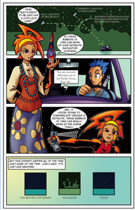
For a more accessible introduction to CINDI we offer our Comic books, in which our Anime/Manga inspired personification of CINDI explains all about the CINDI mission and the science behind it. Our comic books were the subject of a feature article on the NASA website in October 2010. Digital copies of all comics are available free of charge. These comics tell the story of the android space girl Cindi and her two space dogs who explain the purpose of the CINDI instruments as part of the C/NOFS mission and the science involved. These comics are fun and informative for readers of all ages, but the materials are targeted for topics covered at specific grade levels.
For convenience you can get the comics at the links below. For more detailed information on the individual issues and the series as a whole they have thier own section of the site.
Cindi in Space, English: [Color | Black & White] Spanish: [Color | Black & White]
Cindi in the Electric Atmosphere, English: [Color] Spanish: [Color]
Cindi in the Solar Wind, English: [Color]
Exploring Earth’s Atmosphere and Where Space Begins
“How High is Space?” is designed for use in middle grades, but can be used for high school students or informal education as well. Students create a scale model with each piece of 8 1/2″ x 11″ paper representing 100 km of the atmosphere, and a total of eight sheets of paper.
Activity: How High is Space?
Teacher Guide
Student instructions
Layers of atmosphere information
Atmosphere Information Sheet
Model pictures
After years of using this activity with teachers and students, we recommend using the activity the following way, just as we do in our educator workshops:
Materials needed per small group of students: scissors, transparent tape or glue sticks, markers (optional), handouts from this activity (single-sided for the scale model atmosphere and picture pages).
- Give each small group of two to three students the eight model pages to assemble with either tape or glue sticks, along with the sheet of model pictures.
- Have the students assemble the eight pieces of paper into one long sheet, with either tape or glue sticks.
- Ask the students to cut out the model pictures and make predictions, as a group, on where they think airplane, mountain top, clouds, International Space Station, etc., could be found in the model. The three images of C/NOFs, the spacecraft carrying CINDI, for lowest, average, and highest altitudes can be used to discuss satellites with elliptical orbits. (Note: orbits tend to be ellipses, but many orbits, like that of the Earth around the Sun are almost perfect circles.)
- Ask the students to cut out and physically lay the pictures down on their model but NOT to tape or glue down their pictures.
- Hand out the Layers of the Atmosphere Information sheet for the students to work with, and at least Part 1 of the “How High is Space?” student table. (Part 2 involves an investigation for students, and the teacher may wish to create higher order questions than provided. Part 2 of this activity is undergoing revision.)
- Have students compare their predictions with the altitudes given in Table 1, move the pictures to their appropriate locations, and tape or glue them down to their scale model.
- Add layers of the atmosphere, information on density, temperature, etc., as desired.
Scale Model Atmosphere Sheets
In the next activity, “Where Would CINDI Be?” deals with Scale in the Earth-Moon System. The activity is designed to tie into this one, but each can be used independently.
Satellites and Scale in the Earth-Moon System
In this activity, students will make a scale model of the Earth-Moon system. It may be better to initially conceal the intent however. Step by step instructions for the students are given in the provided slides. Below is an outline of the activity. The written lesson plan is pending revision.
Activity: Where Would CINDI Be?
Materials: Play dough (commercially available or homemade in equivalent amounts), rulers (two per group), tape measures, support slides.
- Have students begin with half a standard size (5 oz) container of play dough per group of 2-3 students. Provide at least two rulers (stiff plastic preferred) per small group.
- Ask the students to divide their half container of dough into 50 approximately equal pieces. Having the students think about what to do before they begin dividing their dough is highly recommended. For a mathematics connection, have the groups of students share their strategies with the class.
- Ask the students to select a representative piece from their 50, and set it aside.
- Put the remaining 49 pieces back together, and form two spheres, one large and one small.
- Inform the students that they have just created a scale model in size for the Earth and Moon. The Earth is approximately four times the diameter of the Moon. Have the students measure their model Earth and Moon to see if their model is close to this ratio of 4:1.
- Next, ask the students to predict how far apart the Earth and Moon should be on their scale model “If we could shrink down the real Earth and real Moon to this size, how far apart would they be?”
- Tell the students, as shown on the slides, that the Moon is about 30 Earth diameters away from the Earth. Have them measure out that distance using the diameter of their Earth model times 30. Flexible tape measures, such as those used for sewing work well.
- Have the students predict where the C/NOFS spacecraft carrying CINDI (or the International Space Station) would be found on their scale model of the Earth-Moon system.
- Provide students the measured distance between the Earth and Moon: 384,000 km.
From the “How High is Space?” activity, the distance for satellites in low Earth orbit is about 1/1000th the Earth-Moon distance. So if the distance between the Earth and Moon is 1.5 m, or 1500 mm, the distance for low Earth orbit is only about 1.5 mm!
Additional slides, linked above, discuss adding the Earth-Moon system to the paper model in “How High is Space?”
Rockets
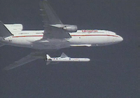
The C/NOFS spacecraft carrying CINDI was launched not from the Earth’s surface, but from under a plane. For CINDI Education we use this uncommon, and interesting launch system as a spring board for lessons to explore Newton’s Laws, projectile motion, design, rotational motion and more.
The satellite carrying CINDI (C/NOFS) was launched from a plane at an altitude of about 12,000 meters or 40,000 feet (near the top of the troposphere) using a Pegasus rocket. Our launch was at night, but here is a video of the daytime Pegasus launch of NASA’s Cyclone Global Navigation Satellite System (CYGNSS) in December 2019. In October 2019 NASA launched the Ionospheric Connection Explorer (ICON) on a Pegasus rocket that contains a UTD science instrument package similar to CINDI. The news article here has a video of the ICON launch at night as seen from the jet plane carrying the Pegasus
Question to spark class discussions: How does launching from a plane at an altitude of 12,000 meters (near the top of the troposphere) instead of the ground help save fuel? How does needing less fuel lower the mass of the rocket? Using Newton’s second law of motion, how is acceleration affected by a lower mass rocket?
Activity: Paper rockets
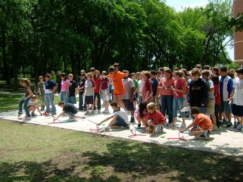
Easy, fast, and inexpensive to make, these paper rockets can be made with regular copy paper and transparent tape. Other types of paper and tape are great for design experiments, too. For launchers, we recommend Stomp Rocket Ultra™, which has an adjustable launch angle and a launcher tube for which 1/2″ PVC pipe makes an easy-to-store and inexpensive rocket mold. We have field tested these rockets with kids in design competitions for grades 5 and up, as well as with teachers. (Note: The “Industrial Strength Rockets” from which we adapted our activity use homemade launchers that degrade with time, and are no longer considered safe by NASA.)
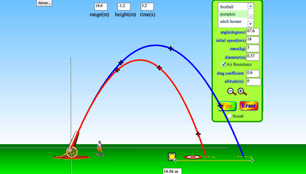
We recommend the projectile motion interactive simulation from PhET (example below), free at phet.colorado.edu (direct link to projectile motion simulation here), for use with this activity to help determine the best launch angle for the rockets.
Space Weather
The Sun’s influence affects the upper atmosphere of the Earth, above the “astronaut altitude” of 80 km where space is defined to begin here in the United States. Our CINDI mission is part of NASA’s fleet of space-based missions studying the Sun and Sun-Earth connections.
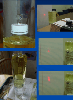
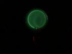
As explained in the CINDI in Space comic book, the type of space weather scientists study with CINDI involves bubbles of ions in the Earth’s ionosphere. Radio waves, a type of invisible light, are bent through these bubbles like visible light is through rising air over a hot road. Our Bubbler demonstration uses water-filled bottles with bubbles of lower density oil rising and distorting red light from a laser.
Demo: The Bubbler and Radio Scintillation
An explanation of what the magnetosphere is, and how it interacts with the solar wind, is provided in our Magnetospheric Information Sheet. You can also learn about the interaction between the Earth’s Magnetosphere and the solar wind with the third issue of our CINDI comic book series and in the video Sentinels of the Heliosphere.8/31/12
Sun-Earth Connection Resources
There is a lot of other sites and material out there that incorporate space science into the classroom. Here are some that relate to the ionospheric studies and space weather work similar to the work of CINDI.
SOHO website This is the website for the SOlar and Heliospheric Observatory (SOHO) spacecraft which is out in the solar wind about 1.5 millions km in front of the Earth. Since its launch in 1995 it has provided continuous monitoring of the Sun and the solar wind and the explosive coronal mass ejections (CME) that come off the Sun.
Space Weather Prediction Center website. The Space Weather Prediction Center is run by NOAA in Boulder Colorado and is the central distribution site for information about current conditions with the Sun and space weather near the Earth.
GEMS Living with a Star Website A website sponsored by UC Berkeley Space Science Laboratory (and affliated with GEMS) with several classroom activities and materials related to space science and space weather.
Great Exporations in Math and Science (GEMS) website GEMS is a project of the Lawrence Hall of Science and UC Berkeley to provide science resource (materials and curriculum) for science and math.
Public Connection A website sponsored by the Rice Space Institute (Rice University) and the Houston Museum of Natural Sciencewhere you can get CDs of astronomy, space science, and Earth science activities and interactive education projects. (Note that the Public Connection is a partner to the CINDI E/PO project.)
STEREO website This is the website for the Solar TErrestrial RElations Observatory (STEREO) mission. STEREO consists of two spacecraft in orbit around the sun, one ahead of the Earth and one following the Earth, so they give us a stereo view of the solar wind and coronal mass ejections from the Sun.
Space Weather Center A website aimed at students to provide material about space science and space weather topics.
Windows to the Universe-Space Weather The space weather section of the extensive astronomy and space science education website Windows to the Universe sponsored by UCAR and NCAR.
The NASA Goddard Space Flight Center’s Scientific Visualization Studio has a variety of animations available in NASA’s Heliophysics Gallery.9/20/12
Videos
Electrons in a magnetic field CINDI Science Team Member, Dr. Greg Earle, demonstrates how electric and magnetic fields affect flowing electrons with a “Complete e/m system” from Pasco.
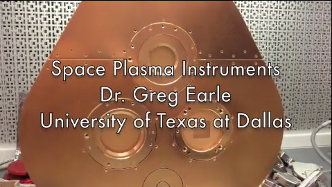
In Virtual Lab/Instrument Tour CINDI Science Team Member Dr. Greg Earle gives a virtual tour of mockups of the ion drift meter in the actual UT Dallas Space Science Center laboratory where the CINDI instruments were built.
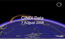
Watch a movie of CINDI data made with Google EarthTM. Actual Data from CINDI is presented with Google Earth, allowing for flows of ions and neutrals to be seen in an orbit to-scale with the planet. Yellow denotes daytime. Blue denotes nighttime.
The Read Me file contains explanations on what the data represents and how the movie was put together. The Google Earth File from which the movie was created is also available.

A time lapse video of actual plasma bubbles as a function of altitude as seen by radar reflections from a radio telescope.
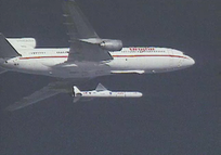
The C/NOFS spacecraft carrying CINDI was launched not from the Earth’s surface, but from the bottom of a plane. Although the C/NOFS launch was at night, we have a movie of a launch system in action, along with other ideas for discussing rockets in the classroom on the Rocket section of this page.
Sentinels of the Heliosphere is an excellent resource for exploring the variety of orbits for NASA’s Sun-Earth observing fleet, the shape of the magnetosphere, and more. The creators describe the visualization as one that “tours the regions of near-Earth orbit; the Earth’s magnetosphere, sometimes called geospace; the region between the Earth and the Sun; and finally out beyond Pluto, where Voyager 1 and 2 are exploring the boundary between the Sun and the rest of our Milky Way galaxy. Along the way, we see these regions patrolled by a fleet of satellites that make up NASA’s Heliophysics Observatory Telescopes. Many of these spacecraft do not take images in the conventional sense but record fields, particle energies and fluxes in situ. Many of these missions are operated in conjunction with international partners, such as the European Space Agency (ESA) and the Japanese Space Agency (JAXA). The Earth and distances are to scale. Larger objects are used to represent the satellites and other planets for clarity.”